Blogs
Automate publishing feature services in AGOL with FME
Introduction
Automating the publication of feature services in ArcGIS Online (AGOL) using the Feature Manipulation Engine (FME) can streamline data management workflows and reduce manual effort. This approach was effectively implemented in a collaborative project to modernize the City of Cambridge's Opeen Data Portal.
Project Background
The City of Cambridge uses a GeoHub to share open data with the public. However, the existing workflow for uploading and updating data involved manual processes with Python scripts, leading to inefficiencies. Our project team developed FME workbenches to replace this process, offering a more accessible solution for team members with limited programming experience.
Methodology
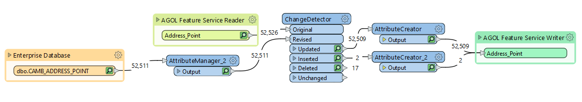
The project involved creating a workflow in FME to extract data from the City of Cambridge’s enterprise geodatabase and publish it to ArcGIS Online. Key steps included:
- 1. Establishing a connection between MS SQL Server and AGOL using FME Workbench.
- 2. Creating dynamic feature readers to automate data selection.
- 3. Using transformers like Tester and Attribute Manager to filter data attributes.
- 4. Publishing feature layers as separate feature services in AGOL.
Automating Updates
An additional FME workflow was designed to detect changes in the enterprise geodatabase and update feature services in AGOL automatically. While FME Server was not available, which limited full automation, the groundwork for future enhancements was established.
Results
The project delivered two primary FME Workbenches:
- 1. One for publishing new feature services to AGOL.
- 2. Another for detecting and updating existing services based on data changes.
The modernized GeoHub now allows faster data updates and a more user-friendly interface, improving public access to data.
Conclusion
The use of FME in this project demonstrated how automating data publishing processes in AGOL can enhance efficiency and reduce the need for manual intervention. This approach not only improves data management but also ensures that open data portals like the Cambridge GeoHub remain up-to-date and relevant for public use.